Lake Oswego Fire Department
District Description The Lake Oswego Fire Department provides emergency response to more than 50,000 residents within the City of Lake Oswego and three adjoining contract districts (Lake Grove Rural Fire District, Riverdale/Dunthorpe Fire District, and Alto Park Water District).
Four fire stations are strategically located throughout Lake Oswego to provide rapid emergency service to residents in need 24 hours a day. Emergency services include fire suppression, emergency medical response, hospital ambulance transportation, water & dive rescue, technical rescue operations, hazardous materials incidents, and disaster response.
Non-emergency services include fire prevention and inspection services, code enforcement, public safety education services, fire extinguisher use, residential safety surveys, home fire escape planning, emergency and disaster preparedness training for citizens (CERT), and fire and life safety education in Lake Oswego schools.
Along with protecting residents within the city and contract districts, the Lake Oswego Fire Department has mutual aid agreements with Portland Fire & Rescue and Tualatin Valley Fire & Rescue, and is a signatory to the Clackamas Fire Defense Board.
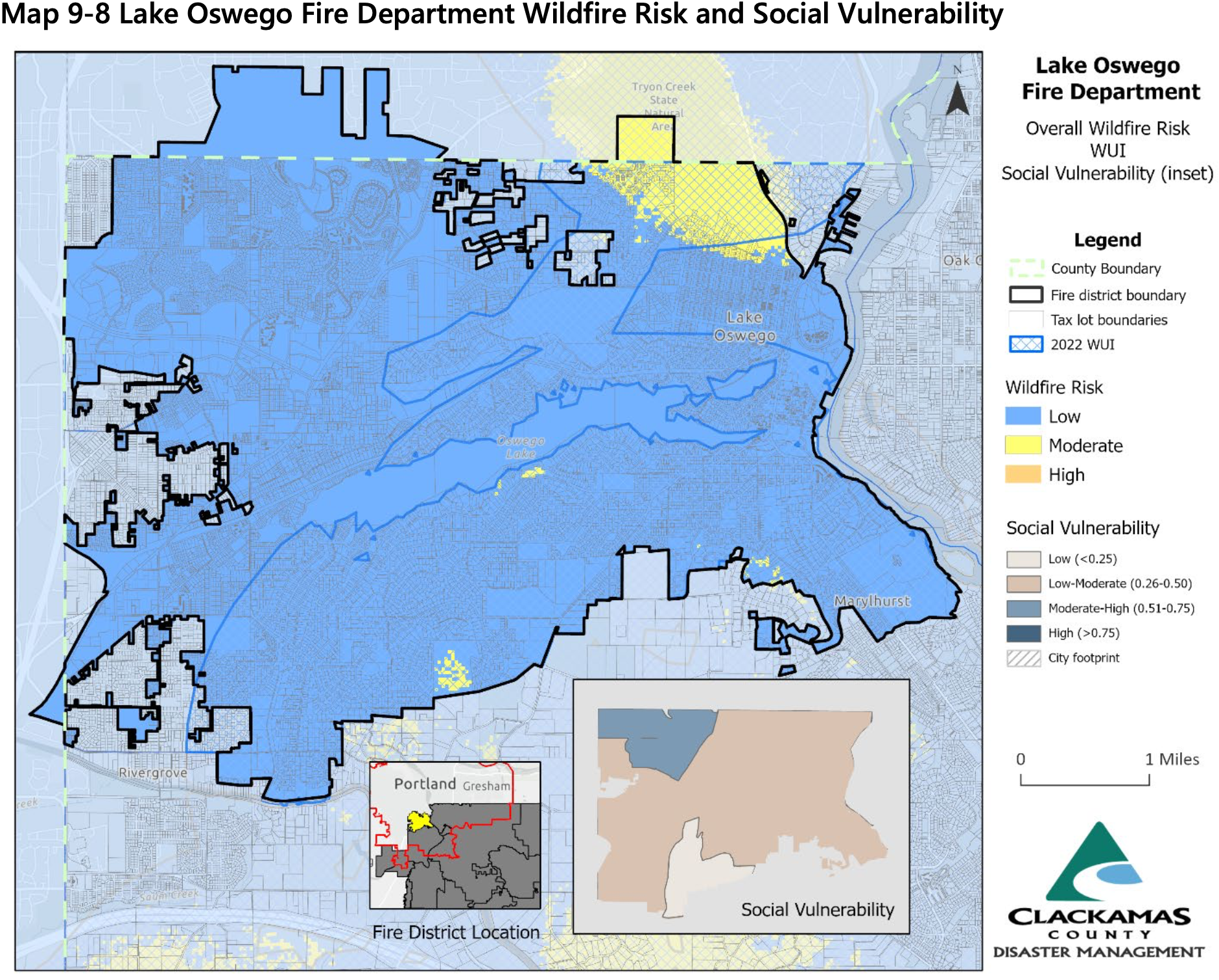
The Lake Oswego Fire Department service area is in Clackamas, Multnomah, and Washington counties. For information on the service area within Multnomah County, see the Multnomah County CWPP. For information on the service area within Washington County, see the Washington County CWPP.
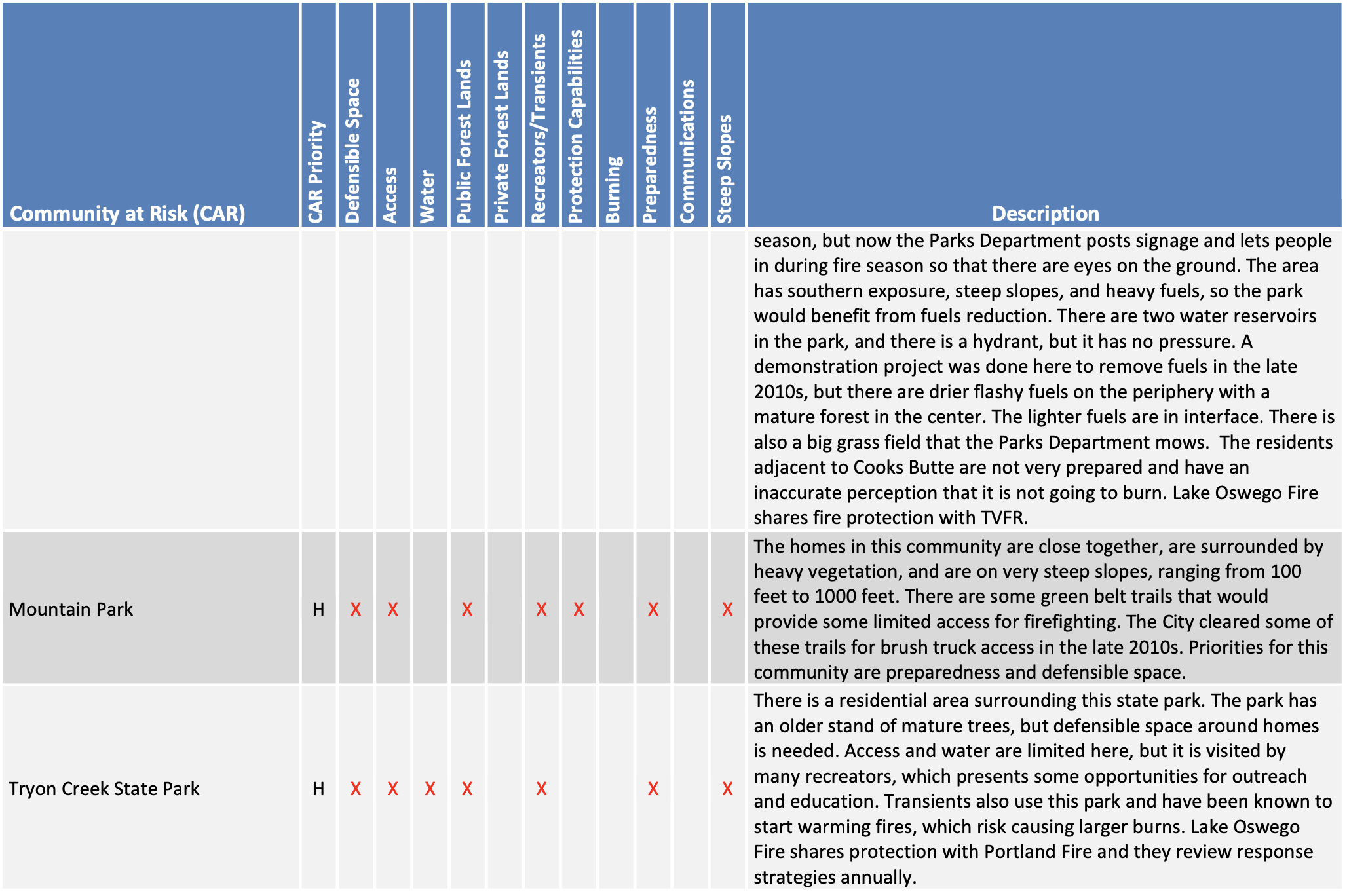
Wildland Urban Interface (WUI) Growth and development in forested areas is popular within the City of Lake Oswego. Wildfire has an effect on development, yet development can also influence wildfire. Owners often prefer homes that are private, have scenic views, are nestled in vegetation, and use natural materials. A private setting may be distant from public roads, or hidden behind a narrow, curving driveway. These conditions make evacuation and firefighting difficult. The scenic views found along Iron Mountain Bluff, Palisades, Mountain Park, and around the lake’s rim can also mean areas of dangerous topography. Natural vegetation contributes to scenic beauty, but it may also provide a ready trail of fuel leading a fire directly to the combustible fuels of the home itself.
The forested hills surrounding Lake Oswego are interface areas. The interface neighborhoods are characterized by a diverse mixture of varying housing structures, development patterns, ornamental and natural vegetation, and natural fuels.
Structural Ignitability The Lake Oswego Fire Department promotes the creation of defensible space, use of fire-resistant roofing and building materials, and community preparedness in the WUI. Lake Oswego Fire works well with other City of Lake Oswego departments to integrate these concepts at the regulatory level by participating in land use reviews for new development to provide input on access and water supply. When they are deficient in access or water, the Fire Marshal’s Office can offer alternative measures such as residential sprinklers. Lake Oswego Fire also approves all occupancy permits to ensure that recommendations regarding access and water supply are implemented.
However, the wildfire hazard remains high in many residential developments. Some conditions exiting in these areas include large houses on small lots, cedar shake roofing, open wooden decks adjacent to heavy fuels, and homes built on steep slopes with wooden stilts as support.
One of the most problematic issues is highly flammable cedar shake roofing. Roofs are the most vulnerable part of the home, as the majority of homes lost to wildland fires are ignited from embers landing on roofs and gutters. Despite this threat, some Homeowners Associations (HOAs) in Lake Oswego still require cedar shake roofs. Lake Oswego Fire would like to reduce the structural ignitability of roofs by educating these HOAs about the risks associated with cedar shake and the viable, attractive alternatives. Lake Oswego Fire would also like to work with the City of Lake Oswego Building Department and Oregon Department of Forestry to adopt a Wildland Urban Interface area that would disallow cedar shake roofs in areas particularly vulnerable to wildfire.
Road access is a major issue for all emergency service providers. Firefighters are particularly challenged by narrow roads with limited access, because the fire trucks are large and the equipment needed to fight fires is located on the trucks. When there is doubt concerning the stability of residential accesses, or adequate turn around space, the firefighters can work to remove the occupants, but saving the structure is difficult. Many of the Communities at Risk (CARs) to wildfire in Lake Oswego exhibit a combination of these issues that limit access.
Although the City of Lake Oswego has a comparatively good water system, additional hydrants could be installed in the Iron Mountain Bluff area and in other communities at risk to assist with fire suppression efforts should they be needed. This and the other issues listed here are addressed in the Lake Oswego Fire Department Action Plan.
Emergency Response Lake Oswego Fire professionals are trained for wildland fires with an annual training regime that supports the S-130 and S-190 with a goal of training staff to S-290. Certification through DPSST is voluntary.
Lake Oswego Fire officials are most concerned with potential wildfires igniting in late summer during an east wind event. A major wildland urban interface fire in Lake Oswego would quickly exceed the resources and capabilities of the Department. For this reason, Lake Oswego Fire has Mutual Aid agreements in place, which allow for the sharing of resources across the county in the event of a large- scale disaster, such as a including wildfire. Due to its location, Tualatin Valley Fire & Rescue or Portland Fire & Rescue in neighboring Washington and Multnomah Counties would likely be the first to provide mutual aid during an event.
Community Outreach & Education Lake Oswego Fire is dedicated to fire prevention and uses a variety of forums to promote residential fire safety, defensible space, and emergency preparedness. Lake Oswego developed an educational hand-out focusing on defensible space and distributed this and other Firewise materials through mass mailings. Lake Oswego Fire has been focused on fire alarms and sprinklers in new construction and emergency preparedness. Fire professionals are invited to speak and provide training in emergency preparedness at Homeowners Association meetings on a regular basis.
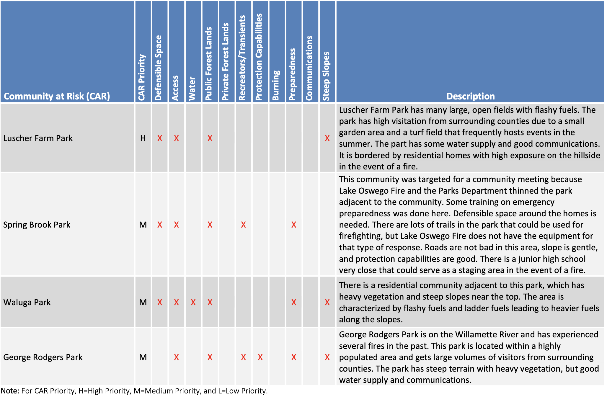
Local Communities at Risk The Lake Oswego Fire Department also recognizes that there are smaller-scale Communities at Risk that have unique wildfire hazards to be addressed at a more local scale. Communities that have been identified as being particularly vulnerable to wildfires are listed in Table 9-15. Lake Oswego professionals considered the following factors to determine the local CARs including:
Need for defensible space.
Access limitations (narrow driveways, lack of address signage, one way in/one way out).
Steep slopes that can hinder access and accelerate the spread of wildfire.
Lack of water available for wildland fire fighting.
Heavy fuels on adjacent public lands.
Potential ignition sources from recreationists and transients.
Agricultural and backyard burning.
Lack of community outreach programs to promote wildfire awareness.
Communications difficulties.
Fuels Reduction Lake Oswego has a very restrictive tree ordinance designed to retain urban canopy for environmental and aesthetic benefits. Currently, homeowners can trim trees and can treat ladder fuels, but cannot cut down any trees that are five inches or great in diameter. Lake Oswego Fire has worked with the City to consider expanding these provisions for the creation of defensible space on residential properties as well as the natural areas managed by the City adjacent to CARs. For example, in 2003 a fuels reduction demonstration project was implemented in Cooks Butte Park and the adjacent community. The Spring Brook Park Homeowners Association has also been successful in creating defensible space around homes.
Since that time, the City has acquired many more natural areas, but very little has been done to mitigate wildfire hazards in these areas. Lake Oswego Fire recognizes the need to work with the City Planning Department in amending the Tree Ordinance to balance the benefits of urban canopy with the risk to life and property from wildfires. To ensure that landscape-level treatments are paired with projects to create defensible space around vulnerable communities, priority fuels reduction projects have been overlaid with the Communities at Risk identified by Lake Oswego Fire.
Fuels Reduction Priorities
Iron Mountain Bluff
Spring Brook Park
Waluga Park
Cooks Butte Park
Tryon Creek
Lake Oswego Fire Department Action Plan Lake Oswego Fire has developed a list of actions to build capacity at the Department scale and has identified actions that can help to make the local CARS more resilient to potential wildfires. The action plan for Lake Oswego Fire and the local CARs therein is provided in Table 9-16.
Progress since 2018 Lake Oswego Fire has been busy making their service area safer from wildfire. Since 2018, they have conducted significant fuel mitigation and water station work in Spring Brook Park, Cooks Butte Park, and with the Iron Mountain HOA alongside ODF.
The Department has completed the following action items from the 2018 CWPP:
2018 Action Item: Work with the City of Lake Oswego to allow exemptions under the Tree Ordinance for the creation of defensible space around homes and fuels reduction in parks adjacent to CARs.
2018 Action Item: Distribute outreach materials that promote defensible space and reduction of structural ignitability within the Home Ignition Zone.
2018 Action Item: Develop a community-driven pre-disaster plan, including evacuation routes, telephone call down trees, and other strategies for strengthening community response.
2018 Action Item: Implement road addressing (including length of driveways) and other signage for emergency response.