Wildland Agencies - ODF/USFS
The communities in Clackamas County that are not covered by a structural fire agency are considered Communities at Risk (CAR) by Oregon Department of Forestry (ODF). Many of these areas are within wildland agency protection boundaries of either ODF or the US Forest Service (USFS). These agencies provide fire suppression for forest land only and do not provide structural fire protection to most of these areas. ODF and the USFS have participated in the Clackamas County CWPP planning process to evaluate capabilities to prevent, prepare for, and respond to potential wildfire events.
Wildland Agencies Area Description In 2004, the Governor’s Fire Service Policy Council convened a task force to discuss the issue of areas that are vulnerable to wildfire but are without publicly funded structural fire protection. This is a major issue throughout the state because the number of structurally unprotected homes in the Wildland Urban Interface (WUI) continues to grow. State firefighting actions on these lands are made possible only after the Governor invokes the Conflagration Act. The task force agreed that protection should be provided only if the county is: 1) completing a community wildfire protection plan; 2) has adopted the Department of Land Conservation and Development’s Goal; 3) requiring fire defense standards for new construction in forest zones; and 4) changing property tax statement language for ODF assessment from “fire protection” to ODF “non-structural fire suppression” so homeowners and insurers are not led to believe they have structural fire protection. The Governor’s Council was reconvened in 2019 and produced a series of recommendations that led to the passage of Senate Bill 762 in 2021, which modernized and improved Oregon’s wildfire preparedness and response. This section of the Clackamas County CWPP addresses structurally unprotected areas, thereby meeting the provisions set forth by both task forces.
There are approximately 722,799 acres of structurally unprotected lands in Clackamas County. The majority of this acreage is Mount Hood National Forest land, private industrial forest land, or undeveloped land. Some small pockets of land do contain a few residences, buildings, and infrastructure that would require protection. These are the areas addressed here. ODF and USFS do provide wildland fire protection to areas without structures, but these areas are not discussed in this section.
Wildland Urban Interface (WUI) Many communities, buildings, and infrastructure in structurally unprotected areas are very rural examples of the WUI. They are characterized by residential homes surrounded by heavy fuels and steep slopes, very limited access, and potential communication issues. These factors, combined with the lack of structural fire protection, make these communities extremely vulnerable. Oregon state law defines the WUI as “a geographical area where structures and other human development meets or intermingles with wildland or vegetative fuels.”
In 2023, the USFS designated the Mount Hood Forest Health and Fire Resilient Communities as one of 21 nationwide priority landscapes under their 10-year Wildfire Crisis Strategy. The USFS’ goal in launching the Wildfire Crisis Strategy was to safeguard communities and the resources they depend on by increasing fuels treatments over time, promoting community readiness, and supporting postfire recovery and restoration. This landscape comprises federal, state, tribal, and private lands on and around the Mt. Hood National Forest (585,348 acres, or 54% of the project area, are on national forest land). The USFS will coordinate all work on national forest system lands with work on adjacent lands in other ownerships. Expected outcomes include fuels reduction in WUI areas, reduced ignition source risks, maintaining and improving critical evacuation routes, and protecting source water areas that provide drinking water to one-third of Oregonians.
Structural Ignitability The Clackamas County Department of Transportation (DTD) notifies local deputy fire marshals of new lots of record to receive input on access and water requirements. In areas that are not within a structural fire agency’s boundary, these requirements may not be adequately incorporated into new development. To reduce structural ignitability, DTD now requires that any new construction must either annex into a structural fire agency’s boundary or contract for structural protection. Lots zoned for Agriculture/ Forestland are required to have fuel breaks, emergency access and turn-arounds, and adequate water supply. Senate Bill 762, passed in 2021, also updates statewide building codes within the WUI to increase wildfire preparedness, reduce ignition risk, and support emergency response.
Emergency Response A major wildland urban interface fire in the structurally unprotected areas of Clackamas County would likely require a multi-agency response. The Oregon Department of Forestry and the US Forest Service are the wildland protection agencies. The USFS and ODF have a mutual aid agreement that allows for the sharing of resources. The Clackamas Fire Defense Board also has a Fire Mutual Aid Agreement that is the vehicle through which resources can be shared across jurisdictional boundaries throughout the County. The USFS is not a signatory to this agreement, so any assistance from structural fire agencies would have to come through the ODF agreement.
Burning of yard waste and debris is a major issue in these communities because backyard burning is responsible for most fire ignitions in the WUI. Many of the structurally unprotected communities are outside of the DEQ’s boundaries, which means they must get permission from the local fire district to burn. Districts regulate what they can but are often too understaffed to monitor such burns. Though ODF regulates illegal burning during fire season, it is not common knowledge and the only burn permits issued are for recreational campfires. This means that backyard burning in these areas is largely unregulated.
The majority of acreage outside of structural fire protection boundaries is in the eastern portion of the county, where VHF is more effective than 800 MHz. Radio communications in these areas can be challenging because 800 MHz is the primary system for structural fire agencies. ODF, the USFS, and the majority of rural structural fire agencies use VHF, so interoperability for a larger scale mutual aid event may become an issue. ODF has a limited supply of portable 800 MHz radios, but the USFS does not. In addition, the USFS does not routinely communicate with structural fire agencies, so there may be confusion regarding communication protocol during a large-scale event. The USFS has identified the need to coordinate radio communications with structural fire agencies in the USFS Action Plan.
Water supply is usually an issue in rural, structurally unprotected areas. ODF and USFS are accustomed to drafting from existing water bodies to supplement water that is brought on scene, and having water sources identified and developed in rural structurally unprotected areas can be critical to response tactics. This has been identified as a need in both the ODF and USFS action plan.
The ODF and USFS utilize permanent and seasonal staff to respond to wildfires. Wildfire training and refreshers are provided annually to remain current on qualifications. Although the wildland agencies can provide classroom training, the lack of live fire experience among some districts makes it difficult to retain wildland qualifications. ODF and USFS are working with the Fire Defense Board to identify opportunities to provide live fire training and prescribed burns to address the fire component of wildland task books.
Community Outreach & Education ODF and USFS are committed to fire prevention and use a variety of forums to promote residential fire safety, defensible space, and safe burning practices. Outreach activities include school programs, public presentations, media events, and safety fairs. The USFS and ODF use fire severity rating signs placed in strategic areas to inform the public about wildfire danger. These wildland agencies are expected to be active members in the newly formed Clackamas County Clackamas Wildfire Collaborative, which is a consortium of structural and wildland fire protection professionals that work together to mitigate wildfire in the county.
Local Communities at Risk ODF and USFS have identified Communities at Risk that have unique wildfire hazards to be addressed at a more local scale. Communities that have been identified as being particularly vulnerable to wildfires are listed in Table 9-25 (USFS) and Table 9-26 (ODF). Wildland Fire professionals considered the following factors to determine the local CARs including:
Need for defensible space.
Access limitations (narrow driveways, lack of address signage, one way in/one way out).
Steep slopes that can hinder access and accelerate the spread of wildfire.
Lack of water available for wildland fire fighting.
Heavy fuels on adjacent public lands.
Potential ignition sources from recreationists and transients.
Agricultural and backyard burning.
Lack of community outreach programs to promote wildfire awareness.
Communications difficulties.
Fuels Reduction The Oregon Department of Forestry has received numerous grants to encourage homeowners and small woodland owners to reduce hazardous fuels through a cost share program. Fuels reduction projects on federal land require an in-depth National Environmental Protection Act analysis that can be costly and time consuming, so completing fuels reduction projects in a timely manner can be challenging. However, the USFS has identified priorities for fuels reduction on federal lands adjacent to communities at risk.
To ensure that landscape-level treatments are paired with projects to create defensible space around vulnerable communities, priority fuels reduction projects have been overlaid with the Communities at Risk identified by Wildland Agency Areas.
Fuels Reduction Priorities
Mount Hood Corridor
Sandy Watershed
NF Bedford
USFS Summer Homes
Kiwanas Camp
Trillium Lake
Wapinitia
Sisi Butte Lookout and Electronic Site
Timothy Lake Area
Government Camp Area
Powerline Infrastructure
Timberlake CCC Job Corps
Ripplebrook Guard Station
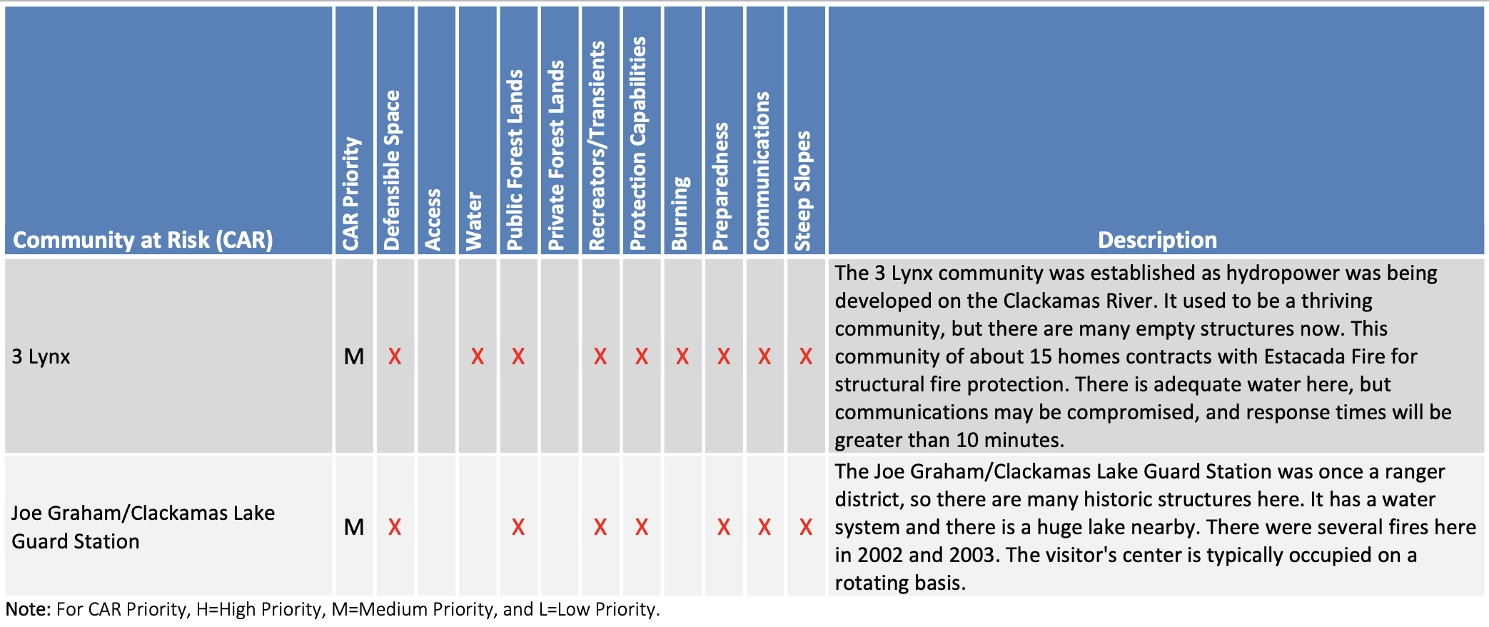
Joe Graham Guard Station
3 Lynx
Zig Zag Guard Station
Bull Run Management Unit and Surrounding Area
Wildand Agency Action Plan The ODF and USFS have developed a list of actions to build capacity at the District scale and has identified actions that can help to make the local CARs more resilient to potential wildfires. The action plan for Wildland Agencies and the CARs therein is provided in Table 9-27 and Table 9-28.
USFS Progress since 2018 The USFS has worked with the Clackamas Fire Operations Group to enhance capabilities for interoperability and obtain a cache of at least five 800 MHz portable radios available for USFS use. They also continue to work with mutual aid partners to determine the best communications strategies (consistent frequency, VHF, and 800 MHz).
ODF Progress since 2018 ODF has worked with most of the fire districts within Clackamas County as well as in structurally unprotected areas to implement road addressing (including length of driveways) and other signage for emergency response. ODF has also provided support in wildfire response and community education, working closely with the Oregon State Fire Marshal (OSFM).