Sandy Fire District
District Description Molalla Rural Fire Protection District #73 (MRFPD #73) is an Oregon special service district that provides fire suppression, prevention, investigation, public education, rescue, and ambulance transport services. MRFPD #73 is approximately 101 square miles with an ambulance service area (ASA) of 350 square miles covering a portion of the neighboring fire agencies and wilderness.
The District operates from three stations: Station 82, the headquarter station in the city of Molalla; Station 81, four miles to the north on Highway 213 near the small community of Mulino; and Station 85, five miles south on Sawtell Road.
Wildland Urban Interface (WUI)The topography of the Sandy Fire District, like most areas in Oregon, is quite diverse. The southern and eastern borders of the District are mostly forested land and the southwest border is the Deep Creek canyon. The Sandy River canyon, which is quite steep and picturesque, dissects the center of the District, and creates an access problem for the northern area of the District, as well as an interface problem with the steep southern bluffs bordering city residential areas. These canyons are forested and have homes built sporadically throughout. This combination of homes, steep topography, and trees pose a significant wildland interface hazard. This topography also impacts communication systems because of slopes that can block radio and cellular telephone signals.
The remainder of the District ranges from gentle hills to relatively flat areas. These areas consist of a combination of farms, homes, and businesses. The nursery business is a major part of local agriculture. There is also a variety of forest lands and natural areas, from thick stands of second growth timber to open grass lands. In addition, public and private management of the surrounding timber lands creates a patchwork of various stages of growth, including slash from logging operations and re-seeding projects.
Tourism and recreation are also huge influences here, with thousands of Portland area residents travelling along Highway 26 to access the Mount Hood National Forest. Campers, hikers, hunters, and other visitors to this area can potentially start wildfires that could carry from public land to the residential communities.
Structural Ignitability Sandy Fire promotes the creation of defensible space, use of fire-resistant roofing and building materials, and community preparedness in the WUI. Sandy Fire works well with the City of Sandy and Clackamas County to integrate these concepts at the regulatory level. In addition, Sandy Fire participates in land use reviews for new development to provide input on access and water supply.
Since the adoption of the county-wide driveway standard, private driveways are being installed that are designed to allow fire engine access. There are several pre-existing private driveways that pose access difficulties like: inadequate turning radiuses; steep grades; inadequate vegetation clearance; and inadequately designed bridges and driveways that will not withstand the weight of a fire engine, especially during the wet season. These factors reduce Sandy Fire’s response time.
Approximately six percent of the District is served by municipal water systems. There are eight water districts serving the District. The major district is the City of Sandy. The City of Sandy also has an agreement with the Portland Water Bureau to provide water via the Hudson/Bluff inter-tie. Other smaller districts include Skyview Acres Water District, Pleasant Home Water District, and Latigo Hills Water District. The remaining water districts serve primarily rural residential communities and are, generally, inadequate for providing fire flow. The remaining 94% of the District uses well water for domestic use. Fire District water tenders provide fire flow for these areas. The water tenders also augment fire flow in hydrated areas if fire flow is inadequate.
Fire flows in the City of Sandy have improved tremendously over the past decade. The City has added another water reservoir, for a total storage capacity of 4.75 million gallons, and has added larger distribution mains to increase available fire flow for much of the City. Its water sources are now capable of producing in excess of three million gallons per day. The City has also identified how the system will grow with new development.
The District has developed strategically located static water sources (ponds and cisterns) in rural areas of the District to assist in fire flow requirements. These drafting locations are documented in fire apparatus books with a description and photos of the site.
For the most part, the transportation system in the District is adequate. There are a few problems that can be directed towards transportation inadequacy, although congestion on Highway 26, through downtown Sandy, is becoming a problem at certain times and days of the week. Highway 26 is a corridor for recreational activities on Mount Hood and in Central Oregon. Funding for maintenance and improvements has shown to be inadequate over the past few years and will continue to be inadequate if sources of funding are not addressed. Clackamas County has undertaken a project called “Concurrency” to further address these issues. Should this trend continue, congestion or the quality of some roads might be an obstacle to emergency response times.
Emergency Response Sandy Fire members are well-trained for wildland fires with an annual training regime that supports task forces and strike teams that respond to local wildfires and conflagrations. Staffing for bigger incidents can be challenging; the District often relies on neighboring agencies for assistance through both Mutual and Automatic Aid agreements. The population is dispersed, which can result in increased response times to outer reaches of the District.
The District has two dedicated Type V brush engines, the latest of which was added in FY 2018/19.
In the event of a large wildland fire, evacuations may be necessary. These rural areas present some difficulties due to the number of residential properties that can only be accessed by one way in and one way out roads. Also, there are many private bridges in the area that may not be able to support emergency service vehicles.
Burning of yard waste and debris is a challenge in the Sandy Fire District because burning is allowed in all areas. Sandy Fire adheres to the Open Burn Policy adopted by the Clackamas County Fire Defense Board and tries to be consistent with neighboring jurisdictions in regulating the Backyard Burning program.

Community Outreach & Education Sandy Fire is dedicated to fire prevention and uses a variety of forums to promote residential fire safety, defensible space, and safe burning practices. The community is very supportive of the Fire District and participates in activities throughout the year, some of which include smoke detector, fire prevention, car seat, and other programs.
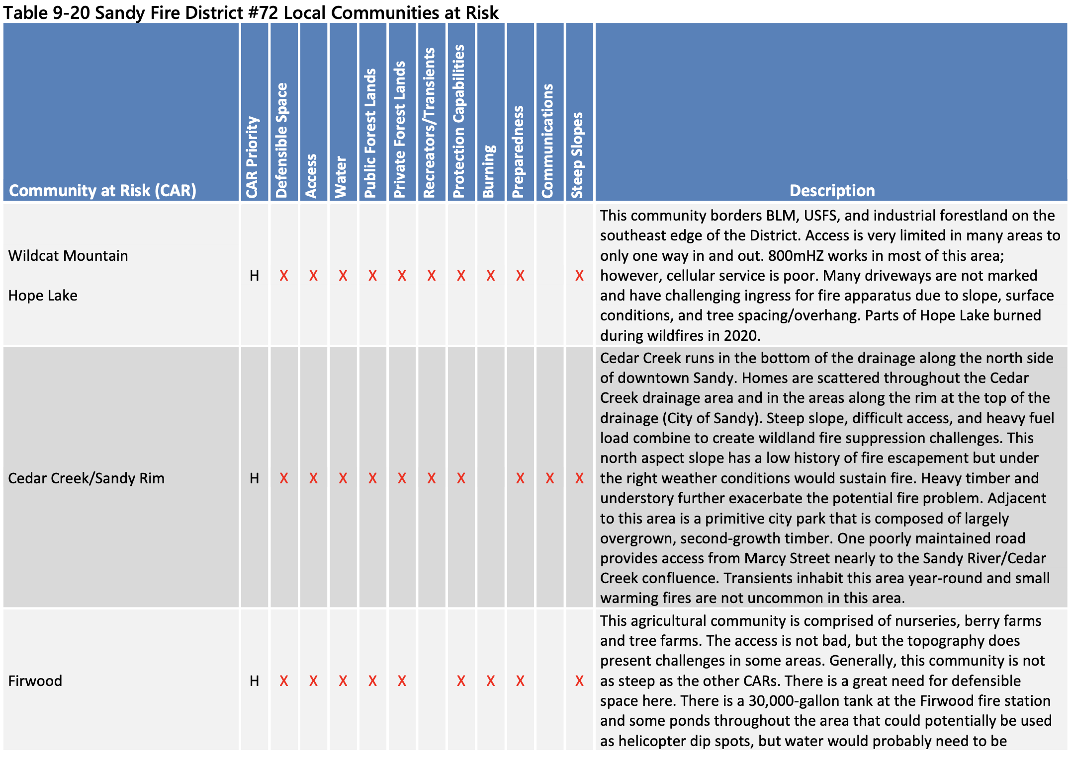
Local Communities at Risk Sandy Fire also recognizes that there are smaller-scale Communities at Risk that have unique wildfire hazards to be addressed at a more local scale. Communities that have been identified as being particularly vulnerable to wildfires are listed in Table 9-20. Sandy Fire considered the following factors to determine the local CARs including:
Need for defensible space.
Access limitations (narrow driveways, lack of address signage, one way in/one way out).
Steep slopes that can hinder access and accelerate the spread of wildfire.
Lack of water available for wildland fire fighting.
Heavy fuels on adjacent public lands.
Potential ignition sources from recreationists and transients.
Agricultural and backyard burning.
Lack of community outreach programs to promote wildfire awareness.
Communications difficulties.
Fuels Reduction Fuels reduction projects can and should be accomplished at the local scale, which is the creation of defensible space around homes, as well as the landscape scale, which is the extension of vegetation treatments onto adjacent forested land and natural areas. Sandy Fire will facilitate cooperation between public and private organizations to ensure that fuels reduction work occurs strategically and benefits homeowners as well as adjacent public and private lands.
To ensure that landscape-level treatments are paired with projects to create defensible space around vulnerable communities, priority fuels reduction projects have been overlaid with the Communities at Risk identified by Sandy Fire.
Fuels Reduction Priorities
Cedar Creek/Sandy Rim
Wildcat Mountain/Hope Lake
Bull Run Watershed
Sandy River Park Area
Sandy Fire District Action Plan Sandy Fire has developed a list of actions to build capacity at the District scale and has identified actions that can help to make the local CARs more resilient to potential wildfires. The action plan for Sandy Fire and the local CARs therein is provided in Table 9-21.
Progress since 2018 The District has completed the following action item from the 2018 CWPP:
2018 Action Item: Develop a community-driven pre-disaster plan, including evacuation routes, telephone call down trees, and other strategies for strengthening community response. difficult to access.